Unlimited users per project to view and use. Image Commenting, Guest Shares & Data Download
Collaborate
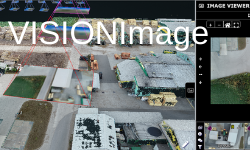
Integrated Point Clouds, LOD Meshes, HD Images, 360 Panoramics, Models, Line Work, Maps, Documents
& Video
View
Create
Deliverables blending 3D data with Images, Orthos, Maps & Documents with Measurements & Annotations
A New Vision for Inspection and Monitoring, Design, Planning, and Asset Management
Your own branded portal for all your survey data– Store and view all your survey data from any source – Point Clouds, Textured Meshes, HD Images, 360 Panoramics, Orthos, Models, Line Work, Maps and Documents – in one place
.
Create and collaborate on deliverables – Whatever your project, however large, use VISION online tools to create powerful deliverables and collaborate easily with stakeholders, on any device, anywhere.
Unlimited Users – in self-contained project UserNets – Control the flow and use of data internally and with clients, without user quotas, and with different user levels of permissions.
Visual quality, accuracy and user experiencecome first– Whatever the device you are viewing on and whatever data you are viewing.
Slottica Casino to doświadczony operator kasyn online, który zaprasza graczy
z całego świata. Kasyno wyróżnia się imponującą różnorodnością slotów,
zabawnymi produktami kasynowymi z krupierem na żywo, a także
ponadprzeciętnymi standardowymi limitami wypłat.
Casino Polska Slottica
to doskonale zabezpieczone kasyno, które zadba o twoje wrażliwe dane i
środki. Doskonały wybór na nadchodzącą przygodę z hazardem.
The overall design of the page is on a minimalistic side of the spectrum,
which means that there are no unnecessary distractions apart from what is of
utmost importance, which is the rich gaming library. Coloration of the site
is in plain white color, making the navigation quite easy and proving to be
somewhat soothing for the eyes.
Najpopularniejsze polskie kasyna online
Polskie kasyna online zyskują coraz większą popularność wśród miłośników
gier hazardowych. Dzięki nowoczesnym technologiom gracze mogą cieszyć się
szeroką gamą gier, od klasycznych slotów po ekscytujące gry na żywo,
wszystko to dostępne z wygodą domowego zacisza. Liczne kasyna oferują
atrakcyjne bonusy powitalne i regularne promocje, które przyciągają zarówno
nowych, jak i doświadczonych graczy.
Ranking polskich kasyn online pomaga
wybrać najlepsze platformy, które oferują najwyższą jakość rozrywki i
bezpieczeństwo.
Rejestracja w polskich kasynach online jest szybka i prosta, a intuicyjne
interfejsy ułatwiają nawigację po stronie i korzystanie z różnych funkcji.
Bezpieczeństwo graczy jest priorytetem, dlatego kasyna stosują zaawansowane
technologie szyfrowania danych i współpracują z renomowanymi dostawcami
gier. Dzięki temu gracze mogą być pewni, że ich dane są chronione, a gra
odbywa się w uczciwych warunkach. Dołącz do najlepszego polskiego kasyna
online i odkryj niezliczone możliwości wygranej i świetnej zabawy!
Answering the needs of the New World of Survey
However, you capture your data……
From the Air with UAV Photogrammetry and Lidar; on Land with Terrestrial Scanners and Mobile Mapping; on or under the Water with Surface Vessels and AUVs.
Whatever your Survey project…..
Inspection, Monitoring, Management or Construction of Transport and Energy Corridors; Power Generation, Oil and Gas Infrastructure; Quarries and Mines; Cities, Buildings, Heritage; Rivers, Ports, Coasts; Forests and Fields.
VISION delivers efficiency at scale
With all your visual and document survey data in one place, easy to use online tools for deliverables and no limits to users, enjoy rapid improvements in project efficiency.
na telefon HitnSpin za darmo: Pasjonujący świat ryzyka i nagród w sercu na telefon HitnSpin za darmo
iphone HitnSpin voucher to miejsce, gdzie emocje sięgają zenitu, a gracze wciągają się w wir niekończącej się rozrywki. Bogactwo gier i unikalna atmosfera sprawiają, że każda wizyta staje się niezapomnianym przeżyciem. Od ekscytujących automatów po klasyczne gry stołowe - tutaj każdy znajdzie coś dla siebie. Nie ma miejsca na nudę w sercu iphone HitnSpin voucher.
Otoczony olśniewającym blaskiem świateł i dźwiękami wygranych, online casino HitnSpin casyno przenosi swoich gości do magicznego świata hazardu, gdzie możliwości zdobycia nagród są nieograniczone. Nasi profesjonalni krupierzy zapewniają sprawiedliwą i ekscytującą rozgrywkę, która trwa przez całą dobę. Czuć tutaj pulsującą energię graczy gotowych podjąć wyzwanie i ryzyko.
na telefon HitnSpin hazard dba nie tylko o rozrywkę, ale także o komfort swoich gości. Luksusowe sale VIP, ekskluzywne promocje oraz doskonała obsługa sprawiają, że każdy odwiedzający czuje się tu jak prawdziwy król. To miejsce, gdzie marzenia o wielkich wygranych stają się rzeczywistością, a pasja do gry towarzyszy każdemu kroku.
Znajdując się w sercu
Hit'n'Spin Casino
, poznajesz świat pełen tajemnic, niezwykłych emocji i spektakularnych nagród. To nie jest zwykłe kasyno - to oaza rozrywki dla wszystkich poszukujących ekscytujących doznań. kasyno internetowe HitnSpin wypłacalne gwarantuje niezapomniane chwile, które pozostaną w pamięci na zawsze. Zanuć melodię wygranej i zanurz się w pasjonującym świecie kasyno internetowe HitnSpin wypłacalne.

")